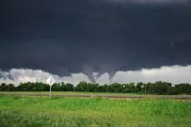
A single storm that crossed Lake Huron two weeks ago has officially been linked to three weak tornadoes in the Goderich area.
Dr. Dave Sills, Director of the Northern Tornadoes Project at Western University, confirmed the news, saying all three tornadoes were rated EF0, the lowest level on the Enhanced Fujita (EF) scale.
The first tornado was seen over Lake Huron before reaching land.
As it came ashore, it weakened briefly, then strengthened again where it caused tornado two and three.
The Porter’s Hill tornado left a track over 6 km long and 200 metres wide. The Harlock tornado covered about 5 km and was roughly 300 metres wide. Despite their size, both tornadoes caused only minor damage.
Dr. Sills explained that the storm began in Michigan and held together as it moved across Lake Huron, something once considered rare.
He mentioned that the change in water temperature could be the cause.
While tornadoes are most common from June to August, July is typically the peak. Sills reminded the public to take all tornado warnings seriously.
Sills also encouraged people to prepare early by securing loose items in their yard and closing all windows and doors if a tornado watch is issued.
The Northern Tornadoes Project will continue to track and investigate severe weather events across the country.